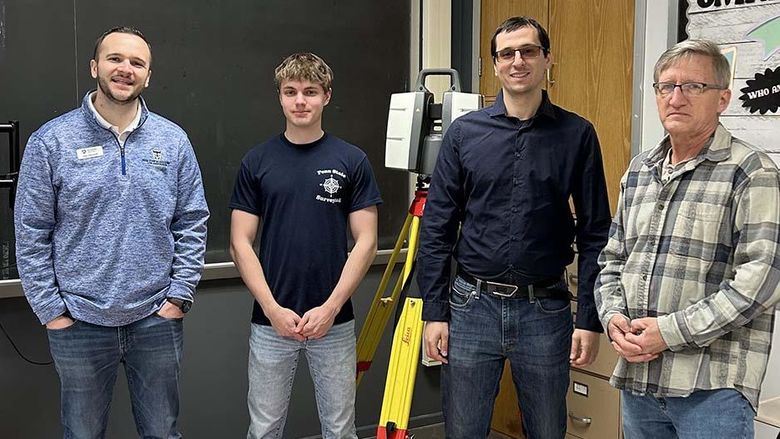
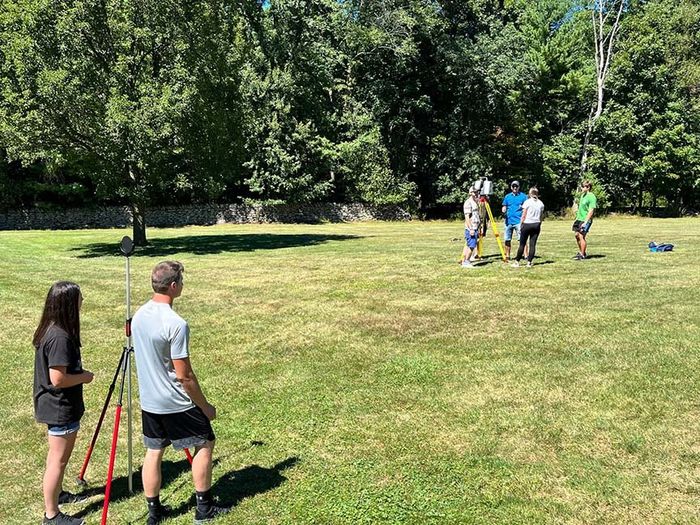
Surveying engineering students at Penn State Wilkes-Barre are able to use the latest in technology and equipment in the course of their studies.
DALLAS, Pa. — Penn State Wilkes-Barre has pioneered education in surveying engineering since it first began offering an associate degree in surveying technology in 1957. A bachelor’s degree program was added in 1994 and the program has continued to evolve and grow since that time.
Today, Penn State Wilkes-Barre is the only university in Pennsylvania — and one of just 25 throughout the country — that offers an accredited bachelor’s degree program in surveying engineering.
One of the initial champions of the four-year degree program, Charles Ghilani, professor emeritus of surveying engineering, is known as a leader in the field of surveying. He arrived at Penn State Wilkes-Barre in 1989 from Wisconsin, where he was born and raised on a farm. Within one semester, he was teaching all the courses in the two-year surveying program at the campus.
The start of bachelor’s programs at Penn State Wilkes-Barre
The four-year program at Penn State Wilkes-Barre — the first at the campus — got its genesis in the early 1990s as part of Ghilani’s desire to give surveying students more opportunities.
“I realized the two-year students I had were baccalaureate quality, but they just didn’t have that opportunity. While a two-year degree gives them an entrance into the field, they hit a career ceiling at a certain point,” Ghilani said. “I saw students who were capable of getting a bachelor’s degree but didn’t have that avenue. I wanted to see what we could do to provide that for them.”
After Jerry Mahun was hired in 1990, the pair began working on developing new associate and bachelor’s degree programs. At the time, only Penn State’s University Park, Harrisburg and Behrend campuses offered four-year degrees.
“The original plan was to create an updated associate degree program that could feed into the bachelor’s program,” Ghilani said. “However, we realized legal and stormwater courses were required for students to be able to pass licensure. We looked at the program and realized there was no way in a two-year program you could study all those things.”
Mahun created course outlines for legal, subdivision design, stormwater and GIS (geographic information systems) courses before moving on, while Ghilani handled the rest of the process, which took two years of him working more than 80 hours a week. That included writing a justification on the need for the program and submitting paperwork and making presentations to the College of Engineering and the University Faculty Senate.
The program was approved in 1993 and in 1994, three students from the two-year program transferred into the bachelor’s degree program as its first students. Ghilani also taught upper-level courses in his office to three associate degree transfer students.
In those early days of the program, the campus had an agreement with the Bureau of Land Management for students to complete paid internships at locations of their choosing, including in Alaska.
“It made a huge change in their lives,” Ghilani recalled. “Several individual students shared stories with me of how they were changed as part of that program. They also got to work with students from other schools and discovered they had a lot more knowledge in their field than students in other programs. Our program at Penn State Wilkes-Barre was fairly advanced as far as what we were teaching.”
Accreditation and more
As the program grew, so did the number of students and faculty. Leaders of the program applied for and received accreditation from the Applied and Natural Science Accreditation (ANSAC) commission of ABET (Accreditation Board for Engineering and Technology) in 2000. ABET accreditation is internationally recognized and provides assurance that a college or university program meets the quality standards of the profession its graduates will enter.
Ghilani said he realized that students in the program were really in an engineering curriculum but not getting credit for their engineering studies, so he decided to make the necessary modifications for the next ABET review in 2005. This modification required all science courses in the program to be calculus-based and that the program’s name be changed from simply “surveying” to “surveying engineering” to reflect its new accreditation.
After the surveying engineering program was created, Ghilani and a colleague were approached by a civil engineering instructor from the University Park campus to create a program that would allow students to get both surveying and civil engineering degrees. For that program, which is still active today, students complete their first three years at Penn State Wilkes-Barre, followed by two years at University Park. This meant that in five years, a student could get two baccalaureate degrees. Students also can complete their bachelor’s degrees in surveying engineering at Penn State Wilkes-Barre.
While Ghilani was helping to develop programs along with pursuing tenure, he wrote two textbooks that are still the top-selling books in the surveying field. “Elementary Surveying: An Introduction to Geomatics” is in its 16th edition and he began writing the book with its 10th edition. “Adjustment Computations: Spatial Data Analysis” is in its sixth edition and Ghilani became its author starting with the third edition.
“I wrote the book so that I had something to use in my classes that undergraduate students in surveying could understand,” Ghilani said. “Adjustment Computations, which is a book on basic statistics and least squares adjustments, is cited in several fields outside of surveying. Both books are used all over the world.”
Ghilani was the founding president of the Surveying and Geomatics Educators Society, president of the American Association for Geodetic Surveying (AAGS), editor of Surveying and Land Information Science, and an honorary member of the Pennsylvania Society of Land Surveyors. He is an AAGS fellow and received the Earle J. Fennel award for outstanding achievements in surveying from the National Society of Professional Surveyors and the Milton S. Eisenhower Award from Penn State for outstanding teaching.
Although Ghilani retired in 2014, he continued to serve on the campus' Industrial Advisory Committee for several years and also provided class notes and videos to support faculty. Ghilani cares deeply about the program, its current students and alumni, and he returned to campus to talk about career paths for program graduates as part of National Surveyors Week events.
Surveying engineering at Penn State Wilkes-Barre today
As the bachelor’s program approaches 30 years at the campus, it is now under the direction of co-coordinators Henrique Oliveira, assistant teaching professor of surveying engineering, and Dimitrios Bolkas, associate professor of surveying engineering.
Oliveira was familiar with Ghilani’s textbooks and had heard of Penn State Wilkes-Barre’s program before coming from his native Brazil.
He was initially surprised by the class sizes, but quickly saw the advantages.
“At first, it was an adjustment for me, since I came from a university with 50 to 100 students in a course,” Oliveira said. “But here, you can have a really close relationship with the students and many one-on-one interactions. Often students get personalized attention. Especially in the labs with our seniors, I am able to just sit with them and work together. The approach is much better in this sense.”
He described surveying engineering — sometimes referred to as geomatics — as “a science and sometimes an art for locating things by providing coordinates.” He said it can be used for mapping properties along with determining locations of accidents, crimes and natural disasters.
“In geomatics, we can go beyond traditional surveying to using new techniques and technology,” Oliveira said. “Geodesy, photogrammetry and GIS are some techniques that help us with this mapping.”
He said that as the field has grown and developed, surveyors are able to acquire much more data in much less time. They are also able to use new equipment in the course of their work.
“We have many new possibilities with new platforms. In the past, it was mainly traditional surveying, using a total station and levels and taking notes,” he said. “Nowadays, for example, you can fly a UAV (unmanned aerial vehicle) to get data, or even use sensors assembled in a car or a backpack. Going beyond the traditional techniques, the new platforms allow us to collect a huge amount of data in a fast way.”
Transition and updates
Oliveira said surveyors across the United States are in a time of transition preparing for a new datum — a set of parameters, data and models that are used as reference for most of the surveys done in the country.
“This is always happening across the world and is now happening in the USA,” he said. “Every survey we do must be linked to this new datum. The last update was about a decade ago, but since it happens over the years, our students always have the background to be prepared for this.”
Oliveira said the program is in the process of getting approval for a new curriculum to bring more technology into the disciplines taught.
“All the background and techniques are mainly the same, but we have different ways to acquire the data,” he explained. “Our courses are mostly a mix of lectures and labs, meaning we collect data outside and process it in the classroom.”
Students also have the opportunity to attend events like the Pennsylvania Society of Land Surveyors’ annual conference, meeting potential employers and connecting with program alumni. Oliveira said several of the students who attended the conference have already received job offers.
“There is a really high need of surveyors and we can tell that by the job offers our students receive,” he said. “The job market in surveying is busy and it’s easy to see that there are a lot of opportunities out there.”
Special activities
The campus planned several activities in recognition of National Surveyors’ Week. All events were held in the Bell Center for Technology.
Events included:
Monday, March 20
10 a.m. – Speech from Charles Ghilani.
11 a.m. – Speech from Stephen Guszick, a Penn State Wilkes-Barre graduate who shared his experience as a surveyor in different areas, including the Army.
3:30-6 p.m. – Scavenger hunt with Girl Scouts.
Wednesday, March 22
1:30-4:30 p.m. – Keystone Precision Solution brought the Mobile Mapping System (assembled in a car) to demonstrate its characteristics, data collection and dataset. Brent Fico presented the possible applications of this type of system.
Surveying engineering students at Penn State Wilkes-Barre get to work with equipment outdoors as part of their studies.