Brothers have killed over it. Wars have been fought over it. Neighbors have fenced it. George Washington, Thomas Jefferson, and Abraham Lincoln surveyed it. It has been stated that over 70% of the World's economy is based on land transactions. The largest branch in surveying involves the creation, delineation, and retracement of land boundaries and is called boundary, land, or cadastral surveying. The oldest types of surveys in recorded history are boundary surveys, which date back to about 1400 B.C. Surveyors during ancient Egyptian times laid-off parcels each spring along the fertile Nile River region after flood waters receded and aligned the pyramids so that their edges were aligned in the cardinal directions of north-south and east-west. George Washington spent a portion of his life subdividing and monumenting lands in the District of Columbia.
As property values increase, the importance of more accurate surveys, monumentation, and written records has also increased. Boundary surveying requires knowledge in both the mathematics of surveying and the land laws. Surveyors are hired by land owners to physically delineate a boundary of their property, and subdivide larger tracts of land into individual parcels for sale. The legal system will ask surveyors to become expert witness during a case involving a land dispute.
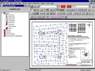 Subdivision of a parcel of land.
In some western states and in Alaska, original land surveys are still being performed. These surveys are based on the Public Land Survey System as originally proposed by President Thomas Jefferson. This rectangular system subdivides lands into grids of about 1 mile square. Because the earth is spherical, north-south lines converge as a survey proceeds to the poles, or goes east-west. Corrections must occur in both directions to maintain the rectangular nature of the system.
Modern land surveyors are confronted with a multitude of problems created over the past two centuries under different technology and legal systems that require professional solutions. In establishing new property lines, and in retracing older ones, surveyors must exercise acute judgment based on education, practical experience, and knowledge of land laws.
To practice boundary surveying, an individual must pass a “minimum standards” exam accompanied with a period of apprenticeship under a licensed surveyor. Since state laws regarding land boundaries vary from state to state, separate licensure is required in all states. A university education in land surveying will provide you with the knowledge you need to start a successful career in boundary surveying.