Surveying is an engineering application of mathematics. Surveyors design and observe systems of observations to create mathematical models of an engineering project. These models are then used by other professions. In some branches of surveying, the surveyor must try to find a coherent solution to a problem that involves the matching of recorded data, legal principles, and measured data. This requires knowledge in several disciplines including mathematics. Below is a common example of an application in mathematics to solve a real problem.
Traditional surveying observations consist of angles and distances to points. For example, assume a surveyor is hired to map the footprint of a building. The surveyor could use a tape to measure each side and by simple addition determine the perimeter. However this would leave the angles at each building corner unmeasured. Since it is impossible to occupy the corners of the building to measure the angles, surveyors establish an arbitrary, local coordinate system that surrounds the building. The coordinate system axes are determined by a single line of what is known as a traverse. In the sketch below, the traverse points A and D were used to establish the Y-axis. The X-axis is laid off at 90 degrees so that an XY coordinate system is established. The remaining points in the traverse, B and C, are placed such that all corners of the building can be viewed. The surveyor observes the distances and angles to each corner of the building. In the following sketch, the distance of 100 ft and angle of 30° from the Y-axis were measured at A. If the coordinates of A are arbitrarily assigned values of X = 0.0 ft and Y = 0.0 ft, then the coordinates of building corner 1 can be determined by solving the right triangle for the change in X, DX, and the change in the Y, DY, using trigonometry. Similarly, the coordinates of corner 2 and traverse point B can be determined. Using the computed coordinates of each building corner, the angles at each building corner, distances along each wall, area of the footprint, and perimeter of the building can be determined.
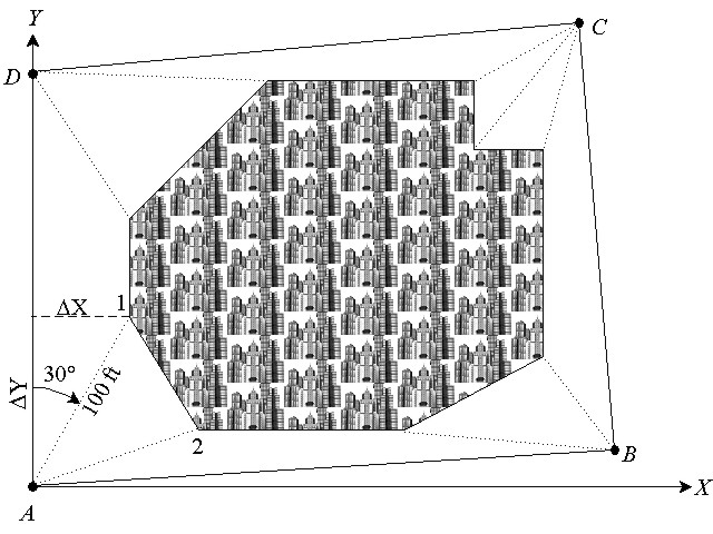
There are many examples similar to this one that are used in construction and boundary surveying. In this example the earth is considered to be flat, or a plane. However for large surveys (those extending more than one mile), earth curvature, gravitational fields, and atmospheric refraction must be considered. Knowledge in the areas of advanced mathematics, physics, and geodesy are needed to perform these computations. A college education will provide you with the background, experience, knowledge, and skill to work in surveying, a field of applied mathematics.
References
- Anderson, J. M. and E. M. Mikhail. 1998. Surveying, Theory and Practice — 7th Ed. The McGraw-Hill Companies, Inc. New York, NY.
- Moffit, F. H. and J. D. Bossler. 1998. Surveying — 10th Ed. Addison-Wesley Longman, Inc. New York, NY.
- Wolf, Paul R. and C. Ghilani. 2002. Elementary Surveying, An Introduction to Geomatics — 10th Ed. Prentice Hall, Upper Saddle River, NJ. 07458.