This dialog contains the full navigation menu for this site.
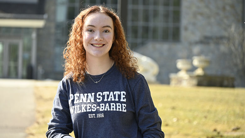
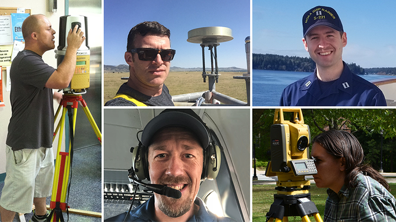
Several graduates of the Penn State Wilkes-Barre surveying engineering program are working with federal government agencies to provide important data for mapping and transportation throughout the United States, from measuring the depths of the ocean to mapping the United States coastline.
Using the lessons they learned at Penn State Wilkes-Barre, all five of of these individuals have taken different career paths to their positions at the National Oceanic and Atmospheric Administration (NOAA) or its subsidiary, the National Geodetic Survey (NGS).
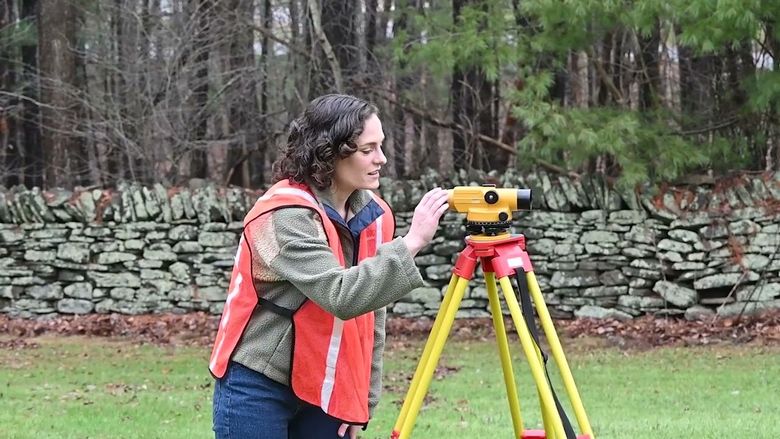
The field of surveying engineering includes land surveying, geodetic surveying, land information systems, construction layouts, and cartography. It involves consultation, investigation, testimony, evaluation, planning, mapping, assembling and interpreting reliable scientific measurements and information relative to the location, size, shape or physical features of the earth, improvements on the earth, the space above the earth or any part of the earth. It also includes how those gathered facts are developed and used. The phrase “global navigation satellite system” (GNSS) is a general term describing any collection of satellites that provides positioning, navigation, and timing (PNT) services on a global basis. The most prevalent GNSS is the Global Positioning System (GPS), managed by the United States.
Ryan Hippenstiel ’02 works as the chief of the Field Operations Division of NOAA’s National Geodetic Survey (NGS). Hippenstiel lives in Chesapeake, Virginia and is based from NGS’ Norfolk office.
In his position as field operations branch chief, Ryan oversees teams that collect geodetic data to support ongoing programs, including the collection of GPS and and other GNSS data along the coast to support sea level work, survey campaigns that contribute to the definition of reference frames, and specialized projects that demand highly accurate geodetic coordinates.
Hippenstiel’s team collects high-accuracy data from across the U.S., its territories, and sometimes international locations, and then provides that data to others to be analyzed by others at NGS. Recently, projects have focused on the Chesapeake Bay, Great Lakes, and Gulf Coast regions.
He also recently served as acting chief of the Spatial Reference System Division. In this temporary role, he oversaw the NOAA Continuously Operating Reference Stations (CORS) Network, which provides GNSS data to support three-dimensional positioning, meteorology, space weather, and geophysical applications throughout the United States. Hippenstiel also managed NOAA’s Online Positioning User Service (OPUS), which provides free access to high-accuracy National Spatial Reference System coordinates.
Hippenstiel started as a secondary education major at University Park but realized it wasn’t the right fit for him. After returning home to Bloomsburg, he “fell into land surveying by chance” when a family friend, who was a land surveyor, offered him a summer position. After a month in that role, he decided to pursue his education at Penn State Wilkes-Barre.
“Once I settled on surveying engineering, that was the only place within Penn State I could get my bachelor’s degree,” Hippenstiel said. “It ended up being a pretty great place to finish my education. The setting is nice and I really enjoyed my time and the people there.”
He completed an internship with the Department of Agriculture through the Student Career Experience Program (now known as a Pathways program) and worked for two summers with the U.S. Forest Service in Arizona, where he accepted a position after graduation. He also worked for a private-sector engineering firm in Pennsylvania and began working for NGS about five years ago.
Hippenstiel said he enjoys the different aspects of each survey project conducted by his team.
“We do a lot of unique projects I never would have imagined doing and go places I never would have imagined traveling to,” he said. “We work with partners like NASA, USGS, and the military. When I was in school, I never would have pictured myself trying to locate and survey a giant antenna or laser responsible for observing outer space.”
“It’s really pretty fascinating work,” Hippenstiel continued. “We provide a lot of data that leads to safe navigation and technical practices.”
Jeff Johnson ’17 works as gravity section supervisor and project manager for the Gravity for the Redefinition of the American Vertical Datum (GRAV-D) project for NGS.
He became interested in surveying engineering when he wanted a career change and decided to return to college in his late 30s.
“I was teaching high school and then started doing construction work building houses. I had a major accident when a concrete truck knocked a pavilion on top of me and I realized I could have died; that’s when I decided I needed a change,” he said.
Aptitude testing and assessments showed an inclination toward land surveying. Originally from central California, Johnson moved to Reading, Pennsylvania, and began researching surveying schools and found Penn State Wilkes-Barre.
While at the campus, he met a representative for NGS through the Industrial and Professional Advisory Council. Through communication with her, Johnson learned of a job opening that he was subsequently hired for.
“I graduated on a Saturday and started on Monday,” he recalled. “It was my dream while at Wilkes-Barre to be part of a large-scale project. While I was there, I started getting this vision of wanting to be involved in more global-scale projects.”
Johnson has achieved that goal by managing NGS’ GRAV-D project, which takes measurements of areas and coastlines around the United States to record the Earth’s gravity signal, which varies due to topography and uneven mass distribution. Based out of NGS’ headquarters in Silver Spring, Maryland but currently working from home, Johnson supervises the gravity team, which takes gravity measurements on the Earth’s surface and in aircraft at 20,000 feet. As part of his duties, he analyzes the gravity data that is used to produce models that will help to protect coastal communities and other communities prone to flooding and plans the logistics of upcoming surveys by NOAA and Department of Interior aircraft.
“I like knowing I’m helping the nation with mapping needs for surveyors,” he said. “I enjoy knowing I’m one small part of a big process to modernize how surveyors access height (elevation) information. It’s great to be part of a project that’s modernizing and making new things as we move into the future.”
Heather Nicholson ’15 is a geodesist for NOAA, part of a team that writes, maintains and tests the software that NGS uses and provides to the general public for GPS and GNSS data processing called OPUS (Online Positioning User Service), which provides access to the National Spatial Reference Frame.
“Geodesy deals with the size and shape of the Earth, its position in 4D space, gravity fields, plate tectonics and atmospheric changes,” she explained. “This relates to surveying engineering because surveyors are interested in putting points on the physical ground based on the reference systems developed and maintained by geodesists. People use things tied to geodesy every day, like online mapping and satellite navigation.”
Like Johnson, she landed on surveying engineering when she wanted to change careers. Her prior degree was in environmental policy, but after deciding to go back to school, Nicholson knew she was interested in geodesy and geomatics engineering.
Originally from the Poconos, she decided to pursue her bachelor’s degree in surveying engineering from Penn State Wilkes-Barre. Nicholson completed an internship with NOAA while an undergraduate, and after earning her bachelor’s degree, she headed to the University of New Brunswick in Canada to earn a Ph.D. in geodesy and geomatics engineering, a program she hopes to complete in about a year. Nicholson returned to the United States during the pandemic and currently works from her home, but is based out of NOAA headquarters in Silver Spring, Maryland.
“It’s nice I can use all of the knowledge I’ve gained and my work experience and apply it to my job,” Nicholson said. “To have that foundation of knowledge is nice to me, and I get to learn new things as I go.”
As a woman in typically male-dominated fields of study and work, she has sometimes found herself surprising others. She recalled one time when she arrived at a construction site to survey and the construction crew assumed she was there to bring coffee. Another time, an elderly woman called the police after seeing her surveying, telling them, “I’ve never seen a woman with a tool like that and I think she’s surveying the neighborhood for nefarious reasons.”
To Nicholson, “we don’t have to distinguish gender” in occupations. “People outside of our field sometimes seem surprised an engineer is female, but this is just a job where we solve problems, which scientists and engineers like to do,” she said. “We like to do math and we like science, and surveying engineering is somewhere between math and science.”
When asked about her favorite part of the job, she said, “I like to be useful. I enjoy troubleshooting and helping people who contact us when they are having an issue.”
Matt Sharr ’14, an operations officer for NOAA, has spent the last year and a half living on an NOAA ship based off the coast of Oregon. Matt works on day-to-day planning and project management for hydrographic surveying and ensures that data is acquired precisely and correctly. The operations he oversees are surveying the seafloor to acquire depth information to update nautical charts.
“Our days on the water start about 8:00 a.m. with a brief about what we’ll be doing that day. Then the survey boats go out and survey all day. After they return to the ship, we process all the data and plan for the next day,” Sharr explained.
He expects to complete his current assignment in September and will then attend Oregon State University to pursue a master’s degree in geomatic civil engineering. Sharr grew up in Avoca and was happy to find a surveying engineering program close to home at Penn State Wilkes-Barre. After completing his bachelor’s degree and an internship at NOAA, he worked for a surveying and civil engineering firm in the Washington, D.C. area before assuming his current role with NOAA.
Sharr said he enjoys working with and teaching others, along with the opportunities for innovation, new technology, and creating new processes that arise in his line of work.
“There are a lot of different uses and potential for the data we collect, including habitat mapping and geology. It’s great when years down the road, you see others using your data,” he said.
The pandemic has significantly changed his work experience, with many added precautions, preparations and testing before everyone boards the ship. Projects at sea that used to last two or three weeks have been extended to 45 days, and when the ship is in port, many employees work remotely.
“A ship is a pretty dangerous environment for having a COVID case, so the pandemic has changed things quite a bit,” Sharr said.
Ryan White ’13 is an OPUS analyst for NGS, maintaining and designing software to compute positions from user-submitted GPS data. He works on projects related to GPS software and planning for future developments in that area.
After high school, White worked as a surveyor but found himself out of work after the housing market crash in 2008.
“I thought it was a great time to go back to school and advance my education in the surveying field,” he said.
White was familiar with Penn State Wilkes-Barre’s program through the Pennsylvania Society of Land Surveyors and felt it was the best option for him. He earned his bachelor’s degree in surveying engineering and then, like Nicholson, he decided to pursue a Ph.D. in geodesy and geomatics engineering at the University of New Brunswick, although COVID pushed back his timeline when he had to return to the United States.
He currently lives and works from his home in southeastern Pennsylvania, based out of NOAA’s Silver Spring, Maryland, office.
“I had wanted a position here for many years, so this was like a dream come true. For those of us pursuing positions outside of licensed surveying work, we like to see what kinds of options are available to us,” White said.
As someone who previously spent time as a surveyor, he especially enjoys helping design solutions for surveyors.
“I like designing tools in such a way that they can be useful to surveyors and designing software I know would have been useful to myself when I was a surveyor,” he said. “I appreciate the feedback from our stakeholders when they say this software has made their lives easier or better.”
While some of these five graduates knew each other from their days at Penn State Wilkes-Barre — or an internship like Nicholson and Sharr — others became acquainted through their work and quickly learned of their Penn State connection.
Nicholson and White were hired into Hippenstiel’s division in the last several months while he was on his temporary assignment.
“My boss had interviewed them and messaged me to say, ‘We have Penn Staters coming on board,’” Hippenstiel said. “Jeff Johnson works in a similar position as I do, and I met Matt Sharr on a NOAA ship at the Marine Operations Center.”
Hippenstiel serves on Penn State Wilkes-Barre’s Industrial and Professional Advisory Council for the surveying engineering program and he, Johnson and Sharr have returned to the campus to give presentations to current surveying engineering students.
Johnson said there are many positions available in the surveying engineering field, noting, “I think it’s a great career to get into and it’s a high need right now. We’ve heard from people at NGS that they have a hard time finding people who are qualified in this field to do the work they’re doing with positioning. If you can learn that foundational knowledge of computer programming, development and application, there’s a lot of room for you.”
Hippenstiel agreed, saying, “I would encourage anyone with skills or interests in math and science to consider going into the profession. I think it’s a really good opportunity to get into a profession that needs more people.”
The alumni said they were ready for jobs in their field because of what they learned in their program at Penn State Wilkes-Barre.
“I thought it prepared me really well for my job,” Johnson said. “When I got my job, I knew a lot of the foundational knowledge I needed to have. The program did a good job of overall preparation and giving me the foundation for what I needed.”
Hippenstiel said, “I think Penn State Wilkes-Barre is a really good environment to learn and to understand the profession. There’s room to spread out and collect data and be outdoors. Getting outside and having that practical experience that Penn State provides is really a good stepping stone and building block for moving into the profession. The campus provided the opportunity to have small classes and a good level of attention from all of our professors.”
Several of the alumni said they didn’t think they would end up in the field they did, but the basic skills they learned at Penn State Wilkes-Barre taught them what they needed to know to adapt and grow.
“Looking at different graduates from our program, you see people go into all different kinds of fields,” Sharr said. “I went in thinking I’d do land surveying and now I’m doing more ocean mapping. But the program and the faculty prepared me with the skills I needed.”
“In our field and in many other fields, it’s more important that we understand concepts rather than memorizing facts,” Nicholson said. “Everything builds on each other and it’s much easier if you understand the concepts when you have to apply them.”
White said, “The surveying engineering degree opens up avenues to aspects of the field you wouldn’t have been aware of beforehand, including much more than licensed surveying work. The quality of the program was one of the best in the world, and the level of instruction we received qualified me for my position.”