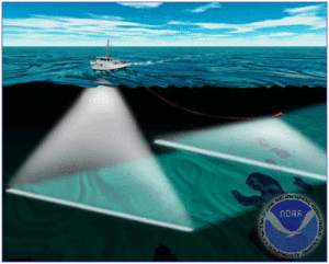
Shipping lanes on the nation's waterways and coastlines are continually shifting as silt moves and accumulates from location to location. Hydrographic surveyors create maps of the bottom of rivers, lakes, and oceans using tools ranging from weights attached to lines, to GPS, to sonar soundings. No matter the method used, the resulting maps are used to aid in maritime navigation, scientific research, sports, and mineral exploration. Additionally hydrographic surveys are sometimes called in after disasters at sea to locate wreckage.